Geophysical mapping of submarine landslides – an introduction into bathymetric and seismic mapping
@ Marum, Bremen | 24-25/11/2017
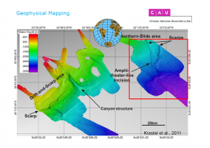
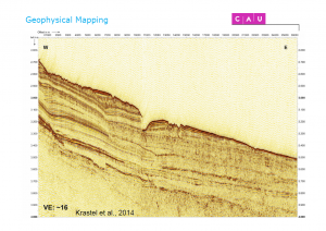
Geophysical mapping techniques provide an essential tool for the discovery of natural energy resources (oil/gas), but are widely applied to scientific problems such as climate research and hazard/risk analysis as well. Acquired datasets proof especially valuable in the recognition of submarine landslides and provide fundamental help in the interpretation of their mechanisms.
The course gives a general introduction into standard mapping techniques and provides examples for their practical application at sea. Type datasets from various locations are used as examples for interpretative analyses followed by a practical excercise. Topics covered are: